Saturday, December 29, 2012

Duskywings: Dreamy vs. Persius

As I seem to only be posting once a month, I figured I had better put something together before the new year!  Between being sick for a week and busy with Thanksgiving and Christmas, I haven't had time to work on the guide to preserve and mount specimens as I promised in my last post, but hopefully I will get to that soon.  In the meantime, I thought I might give you a lesson in differentiating Dreamy and Persius duskywings (Erynnis icelus and persius), mostly because that is what I've been struggling with today while working on my Sinlahekin butterfly guide.  I'm fairly certain that I've identified these photos correctly, but if anyone reading this disagrees, please let me know by leaving a comment, I'd appreciate it!

Dreamy Duskywing Erynnis icelus
This is the only duskywing species in the Northwest that does not have the group of submarginal white spots on the dorsal forewing.  Dreamy Duskywings also tend to have a more purplish-gray frosted appearance, compared to the brownish-gray of the Persius Duskywing, although this is not a reliable method of identification.  The Dreamy Duskywing's larval host is primarily willow, and the adults are frequently found in moist meadows and along streams where willows are found.
Dreamy Duskywing, Sinlahekin Wildlife Area, Okanogan County, WA

Persius Duskywing Erynnis persius
Persius Duskywings have a group of submarginal white spots on the dorsal forewing that set them apart from Dreamy Duskywings, although these markings are difficult to see in faded individuals.  Larval host plants are primarily lupine species, although species of milkvetch (Astragalus) and deervetch (Lotus) have also been recorded.
Dreamy (left) and Persius (lower right) duskywings with Boisduval's blues, SWA
Persius Duskywing, Sinlahekin Wildlife Area, Okanogan County, WA

Saturday, November 17, 2012

Mapping butterflies

This is the time of year when I spend more time working on my butterfly mapping projects (and forgetting to work on my blog, sorry for the sparse posts!).  Now that I'm mostly settled in for the holidays and not traveling hither and yon chasing butterflies, it's time to start mounting all the specimens I've collected over the summer and catch up on some of my projects.  I thought I would share a little about the process of what I do; this post will be about how I map butterfly locations and ranges, and later I will post an illustrated guide of how to preserve butterfly specimens.
There are several ways to illustrate the range of butterflies.  First, you must decide whether you will map them by point location or general location.
Point locations are more accurate of course, because they show the exact location where a butterfly was observed.  If there are many records, patterns may begin to emerge that can be useful in studying the habitat and range of the butterfly, as well as identifying hotspots - areas with a high density of individuals.  A single point away from the main cluster of points might indicate a butterfly that has strayed from it's normal range, or it may identify an area that is under-sampled and should be surveyed to determine if there are more butterflies in that area.  Mapping point locations is limiting however, as many records (especially historic records) might not have exact location information.  It is also more difficult to illustrate the range of the butterfly at a large scale, such as on a world map, because areas with single or few points might not show up as well.
General locations can be mapped at a scale almost as detailed as a point map, or as broad as what you frequently see on world maps.  For example, the size of North America maps that you see in field guides is quite small, so if a boundary line is several miles from where it should be on the ground, the difference would only be a fraction of an inch on the map, therefore the cartographer (person making the map) doesn't need to worry about being very precise.  If a map is smaller scale, the cartographer must spend more time drawing accurate ranges.  For some maps, illustrating species locations by a standard set of data is beneficial because it reduces the need for the cartographer to interpret and draw the range location.  For example, British studies have used a grid of 1 kilometer squares to survey and map butterfly locations, and many North American birders use a township grid for their surveys.  Because sections (1 square mile) and townships (6x6 sections) are a surveyed grid system in most of the USA, and the data for most states is available for free download to be used in GIS (geographic information system, a mapping program), this grid system is great for mapping general butterfly locations.  The sections can also be subdivided into quarter sections or smaller, providing a wide range of possibilities for mapping records.
Map of Lycaena heteronea (Blue Copper) by quarter-section squares in the Sinlahekin Wildlife Area.
Using GIS to make maps provides nearly endless possibilities, and there are many ways to obtain or create the features that make up the map.  A lot of the basic features, such as major roads, lakes, rivers, cities, and the township grid are available through county, state, or departmental websites, often for free download.  To make a map like the one above, I downloaded the DEM (digital elevation model) for this area and created a hillshade (the topographic shading) using a tool in GIS.  I also obtained a 2011 aerial photo of Okanogan County, which I used to digitize all the lakes, ponds, wetlands, streams, and roads in this area of the SWA.  Digitizing (drawing features on the computer) takes a lot of time, but it allowed me to create the most accurate features for my map, since most of the data I had was fairly rough and didn't quite match up with the hillshade.  Once all the features are complete, I format the labels and experiment with different colors and shading to make everything as easy to read as possible.  The final step is adding the butterfly records for each species, which actually takes longer than a lot of the other digitizing, because of the time it takes to compile all the records and verify the information, before adding it to the map.  The finished product is worth the effort though!  Now when I visit the Sinlahekin, I have been able to focus my time on areas with no mapped records, in order to produce the most accurate map possible.

Saturday, October 27, 2012

'tis the season!

Keep a lookout for woolly bears and other caterpillars this time of year.  By now, many of them have found their winter hiding places, often in your woodpile or garage.  Some butterflies and moths overwinter as adults, such as members of the Nymphalidae butterfly family, including Mourning Cloaks (Nymphalis antiopa), Compton's Tortoiseshells (N. j-album), and Milbert's Tortoiseshells (Aglais milberti).  Other butterflies, such as Monarchs (Danaus plexippus) and Painted Ladies (Vanessa cardui), fly south for the winter because they cannot survive our cold winters.  Some California Tortoiseshell (N. californica) butterflies overwinter locally, while many have also been seen migrating southward along the Oregon Coast.
This is also the time of year when I pick out a few moth pupae and sometimes a few butterfly chrysalids from Bill Oehlke, manager/creator of the "World's Largest Saturniidae Website".  He offers livestock for sale that have been reared either by himself or other legitimate dealers.  I've dealt with him on and off for the past ten years and have always been pleased with the livestock.  So far I've obtained the following species from him:
Actias luna - Luna moth
Antheraea polyphemus - Polyphemus moth
Automeris io - Io moth
Callosamia angulifera - Tulip Tree moth
Callosamia promethea - Promethea moth
Citheronea relgalis - Regal moth (larva is known as the Hickory Horned Devil)
Hemileuca nevadensis - Nevada Buckmoth
Hyalaphora cecropia - Cecropia silkmoth
Hyalaphora euryalis - Ceanothus silkmoth
Hyalaphora columbia - Columbia silkmoth
Samia cynthia - Cynthia silkmoth
Papilio cresphontes - Giant Swallowtail
Papilio glaucus - (Eastern) Tiger Swallowtail
Papilio troilus - Spicebush Swallowtail

Yesterday I received my newest order: Pipevine Swallowtail Battus philenor and Rosy Maple Moth Dryocampa rubicunda.  I've never reared either of these species, so I'm excited to see what the freshly-emerged adults will look like, but I'll have to wait until next Spring!  The Ruby Maple Moth pupae are really fascinating, all the moth pupae I've reared in the past have been smooth, but these are covered in tiny spines, mostly on their heads and in rings around each body segment.  You can see some of the spines in the photo here.
Pipevine Swallowtail (2) and Ruby Maple Moth (7) pupae. Each of these is about 1 inch long.

Tuesday, September 4, 2012

Aftermath of the Taylor Bridge Fire

Please read the previous post first: How Does Fire Affect Butterflies?
Heading north on Highway 97, this is the southern-most reach of the fire, closest to Ellensburg.
North on Highway 97, one of several places where the fire jumped the road.
Red fire retardant still stains the highway.
The property of a couple my dad knows, who lost their mobile home and shop.
One of many close-calls, where a home was saved.
New poles along Bettas Road, where the old ones burned down.
Parts of the guard rail along Bettas Road were burned where the fire crossed the road.
Large portion of the guard rail posts burned here.
Looking north from Bettas Road
One of the 51 homes that burned, this one is on Bettas Road.
A new house going up that was spared from the fire (incidentally my dad is going to roof this one)
Looking southwest, back towards Bettas Road (through the valley) from Highway 97.  The red house on the hill is the one seen in several news articles, showing the fire burning around it and everyone was surprised when it survived.
Another view of the valley.
This is just north of the previous two photos, showing the red fire retardant dropped along the ridge.
Scorched area along Highway 97
New pole (left) and burned area along Highway 97
Burned bridge leading to the home in the previous photo.
View from Smithson Road east of Highway 97, showing the burned ridge.  Click on this photo to view full-size.
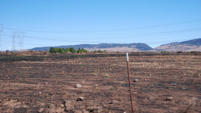
Burned area along Lower Green Canyon Road, south of Reecer Creek Road.  Click on this photo to view full-size.
Corner of Lower Green Canyon Road and Reecer Creek Road.   Click on this photo to view full-size.
View of the burned area from the southbound I-5 viewpoint on Manastash Ridge.  Click on this photo to view full-size.
Close-up of the eastern-most reach of the fire.  Click on this photo to view full-size.

Question Series: How does fire affect butterflies?

Labor Day weekend is always "fair time" for me, as the Kittitas County Fair and "world famous" Ellensburg Rodeo occurs over the holiday weekend.  This year, I visited my parents in Ellensburg, and went to the fair on Saturday to give series of 10-minute butterfly presentations over a two hour period at the old schoolhouse in the "pioneer village" at the fairgrounds.  On Monday, my parents gave me a tour of the area northwest of town that had burned (the Taylor Bridge Fire burned 23,500 acres and 51 homes about two weeks ago).  I took several photos that I will post separately, but first here is my answer to a question my mom asked, and others may be wondering as well: how does this and other large fires affect butterflies and other insects?
Escape
During the first few days of the fire, I read many news articles about the destruction and evacuations, nervously waiting to hear whether some friends had evacuated or if the fire was threatening their homes (everyone I know is safe, although some were quite close to the fire).  In one article (about half-way down the page), I read that "swarms of grasshoppers" were seen crossing Highway 97 in an attempt to escape the fire.  I am not familiar with grasshoppers enough to know why they were crawling and not flying, although they may have been nymphs; immature grasshoppers that do not have functioning wings and therefore must crawl instead of fly.  Adult butterflies could potentially fly out of the way of a fire, particularly strong fliers such as swallowtails and nymphalids (brush-footed butterfly family).  However, this fire was moving at least 25 mph in some places, and wind gusts were reaching above 30 mph.  In addition to the suffocating smoke, the fire was moving so fast that I doubt many butterflies and other insects would have been able to leave the area in time, not to mention all the eggs, larvae, and pupae that are incapable of outrunning a fire.  
While they may not outrun it, there are ways they can escape harm if the fire is burning naturally at a low intensity.  Larvae of some species seek shelter during the day by hiding at the base of their host plants or shrubs, either under the duff or in loose soil and rocks.  Butterfly species whose larvae feed on trees or tall bushes may escape low-intensity fires if they are high up in the plant.  As you'll see in my photos, some areas were completely scorched, while other areas were only lightly burned, leaving many bushes and trees with green tops.
Repopulation
Fire is a natural occurrence in nature that helps balance and restore ecosystems, restarting a process of ecological succession.  Ecological succession is the process of change in a community of plants and animals.  Over time, duff (dead plant material) builds up and can choke out plants and prevent new plants from sprouting.  Fire clears areas of duff, brush and trees, and returns nutrients to the soil.  This opens up new habitat for wildflowers and grasses, and eventually more bushes and trees, along with the animals that are associated with each type of plant.  If an area is prevented from burning for many years it can disrupt the natural cycle and allow a buildup of dead plant material, so that when it finally burns, it burns much hotter than normal.  An unnaturally hot fire will kill not only many seeds, but also any insects or other animals hiding just underground or in other areas that would be protected in "cool" fires.Although butterflies are killed by fire, it is their friend in the sense that it renews and protects their habitat by allowing many of their larval host-plants and nectar flowers to flourish.  It is well-documented that only a year or two after a fire, butterfly numbers are often higher than in years before the fire, due to the new flush of plants.  Butterflies and other insects re-colonize burned areas from surrounding un-burned habitat, which is why it is critical that fires (wild and prescribed) are not over an area that would destroy an entire population.  Un-burned islands within the fire perimeter also contribute seeds and animals to the recolonization of the burned area.
The area northwest of Ellensburg may be charred and black right now, but some areas area already turning green with new blades of grass, and next spring the hillsides will be covered with grass and flowers bolstered by the new source of nutrients, attracting new butterflies and other insects, which will likely abound in another couple years.
Grass is already coming up in this blackened area along Reecer Creek Road